Mar 23 2010
Operation IceBridge mission, NASA’s largest airborne survey of the Earth’s polar ice, commences its second year of investigation with the arrival of NASA aircraft on March 22, 2010 in Greenland.
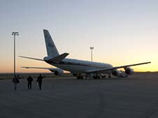
 NASA's DC-8 Aircraft
The mission will enable the NASA scientists to track changes related to thickness and extent of the ice existing in the polar region, which will be a key input that helps understand the dynamics of ice. The mission commenced during March 2009 for filling up the void created in polar observations due to the loss of the ICESat, also known as the Ice, Cloud, and Land Elevation Satellite, of NASA and the propose launch of ICESat-2 in 2015. NASA missions will fly over the Antartica during October and November and the Arctic region during March and April every year.
According to Washington-based NASA Headquarters’ cryosphere program manager, Tom Wagner, the mission is analyzing the changes taking place in the polar ice sheets of the world. Wagner explained that the mission aims to collect critical data to help enhance predictive models used to detect global climate variations and increase in sea levels.
NASA researchers are planning to repeat surveys conducted on earlier ground tracks and flight times of the ICESat mission, besides including more areas of research interest. These research scientists will also focus on regions that are undergoing mystifying transformations. For example, the large-sized southeast Greenland glaciers thinned simultaneously in the past. However, some of these glaciers are thinning at an increased rate, up to 40 feet a year, while some of the glaciers have thickened. Further, the erstwhile stable northwestern Greenland glaciers are now thinning.
NASA engineers are installing a range of scientific instruments in the DC-8 aircraft of NASA to prepare for the 200 h of flight experiment in the spring 2010 campaign.
The aircraft will reach Thule, Greenland on March 21-22, 2010 where the NASA crew and researchers will send five weeks to prepare for 10 to 12 scientific flights. As their first priority, these scientists will survey the sea ice in the Arctic region, which peaks to maximum extent during March or early April every year. The outlet glaciers and ice sheet of Greenland will also be surveyed using flights from low and high altitudes.
The science instruments will be shifted to more mobile and smaller P-3B aircraft by the NASA engineers during mid-April 2010. The crew will conduct 10 to 12 science flights in May 2010 over the Thule and Kamgerlussauq regions of Greenland.
Project scientists Michael Studinger from the Goddard Earth Science and Technology Center at the University of Maryland and Lora Koenig of Goddard Space Flight Center of NASA in Greenbelt, Md are in charge of the spring flights. Other members of the mission include technicians, crew, and scientists from Wallops, Goddard, Dryden Flight Research Center of NASA in Edwards, California, the University of Washington, the University of Kansas, Palisades, N.Y.–based The Earth institute at Columbia University, and the Moffett Field, California-based Ames Research Center of NASA.
Scientists will also be able to make new observations that are not possible at present using satellites due to versatility of these aircrafts. Columbia University’s gravimeter and University of Kansas’ radar instruments will empower scientists to observe ice, snow, and bedrock features at depths under the ground surface. This information will enable scientists to better understand the ice sheet and glacier process and enable scientists to predict future behavior of glaciers.
According to John Sonntag, a member of the management team of IceBridge and URS Corporation’s senior scientist in Wallops Island, Va., NASA has an exceptional capability to observe ice transformations through a bird’s eye view from space, as well as from high-performance and multiple long-range aircraft. Sonntag revealed that without the IceBridge mission, the worldwide science community will miss a large amount of information related to Antarctica and Greenland.
Source: http://www.nasa.gov