I’m the Landsat 9 Project Scientist, with NASA Goddard Space Flight Center in Greenbelt Maryland. As a Project Scientist, my job is to ensure the scientific integrity of the Landsat 9 mission. That includes coming up with the mission requirements, assessing the performance of the instruments relative to those requirements, and advising the Project on how the data products will be used by the community.
My academic background is in Geology, and I started working with remote sensing imagery in Grad School. From there, I became interested in global vegetation dynamics sensed by satellite records and became increasingly involved in the Landsat Program. I joined NASA GSFC in 2001.
Since the 1990s, my research has focused on how global vegetation and land cover changes through time. I’ve worked on creating a satellite-based history of forest disturbances (fire, harvest, storm damage) for North America, and on how warming temperatures are affecting vegetation cover at high latitudes. Both of these projects were supported by the Landsat archive.
Landsat 9 hopes to build on the data obtained by current Landsat satellites, working in partnership with Landsat 8 to monitor changes to the Earth’s surface. What are the primary Landsat 9 mission outcomes, and how will they help to improve current research?
Landsat 9 will fly with its sister satellite, Landsat 8 (which was launched in 2013). Like all Landsat missions, Landsat 9 was built by NASA GSFC, and will be operated by the US Geological Survey (USGS), which also archives and distributes the data products. We like to have two Landsat platforms in orbit simultaneously – each imaging the global land area every 16 days.
With two satellites we can image those areas every 8 days, which is a key requirement for agriculture and other applications. Landsat 9 replaces the older Landsat 7 and represents a step up in terms of image quality and data volume. Having two state-of-the-art platforms in orbit means more frequent data with excellent image quality.
Landsat technologies are a keystone satellite-based monitoring system. With the release of Landsat 9, more detailed observations of coastal waters, coral reefs, and dense forests are possible.
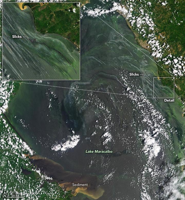
Landsat imagery. Image Credit: NASA Goddard Space Flight Center and U.S. Geological Survey
What is the significance of this ability when understanding how climate change is affecting global ecosystems and how can this help to design better mitigation strategies?
The key role of Landsat in the context of climate change is to document the impact of climate change on global ecosystems, which is highly relevant for the future availability of food, water, and fiber resources, as well as the provision of ecosystem services including biodiversity. In thinking about how climate change affects ecosystems, many of the changes we see are slow and relatively subtle over the time scale of a single satellite mission.
For example, in Siberia we’ve seen the gradual replacement of Larch with dark conifers over the last several decades. In tropical coastal regions, we see progressive bleaching of corals over the same time period.
Having a carefully calibrated multi-satellite record allows us to ensure that we are recording changes to the Earth, and not simply changes in the instrument response. The more detailed observations from Landsat 8 and Landsat 9 allow these subtle changes to be teased out of the long-term record unambiguously.
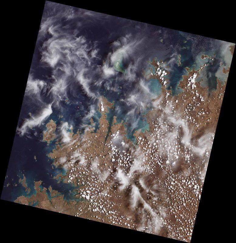
Mangroves are prominent along the northwest coast of Australia. The first image collected by Landsat 9, on Oct. 31, 2021, shows mangroves clustered in protected inlets and bays on the edge of the Indian Ocean. Fluffy cumulus clouds and high-altitude cirrus clouds hover nearby. The aqua colors of the shallow near-shore waters give way to the deep, dark blues of the ocean. Image Credit: NASA
Part of Landsat 9’s capability enables short-term changes to be observed, such as monitoring the growth of farm crops over a season. Why is it important to track this to help implement more sustainable solutions in the agricultural industry?
Crop growth stage and health, including effects of drought and disease, vary from week to week. When you factor in data losses from cloud cover, the 8-day revisit from Landsat 8 and 9 together is the minimum needed to provide effective management information. It is even better to incorporate additional sources of data, such as the European Sentinel-2 satellites or data from commercial sources, to augment the Landsat capability.
While individual farmers may use data from Landsat, the real role of the system is to provide a more regional view of conditions, for example, to support crop insurance programs, allocations of water resources, or understanding of regional food security in the developing world.
One of the many applications of Landsat 9 is the ability to map disasters. Could you explain how Landsat 9 is able to do this, and how this data can potentially be used to save lives?
The role of Landsat in disaster response depends on the type of hazard. In the case of wildfire, Landsat provides seasonal data on shrub and grass cover that can inform fuel loading maps and thus fire risk assessments. After the fire, Landsat is used to assess the severity of the burn, and to monitor ecological recovery in the following years.
Landsat can map out the extent of flooding and seasonal inundation events. The thermal and shortwave infrared channels are used to look for volcanic “hotspots” that may be indicative of forthcoming eruption.
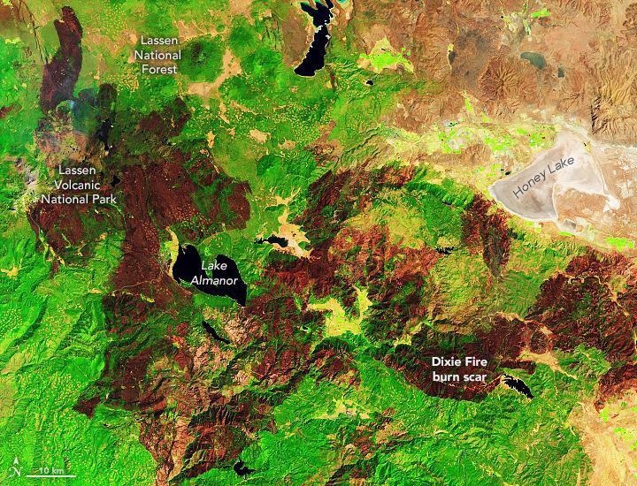
Landsat imagery. Image Credit: NASA Goddard Space Flight Center and U.S. Geological Survey
An Infrared sensor is a major component of Landsat 9’s observation system. Why is this type of sensor a useful tool for monitoring changes to the Earth’s climate and ecosystems?
The Thermal Infrared Sensor 2 (TIRS-2) aboard Landsat 9 measures radiation emitted from the Earth in the 10.5-12 micrometer part of the electromagnetic spectrum, and this can be converted to maps of surface temperature. A primary use of these maps is to measure the amount of water that plants, especially crops, consume during growth.
Transpiration of groundwater by plants cools their canopies, and this cooling can be measured by TIRS-2. A key benefit of monitoring this “evapotranspiration” is that it can provide early detection of drought stress in crops, and also provide information as to whether too little or too much irrigation is being applied. That’s important in a warming world, where water resources may be more limited.
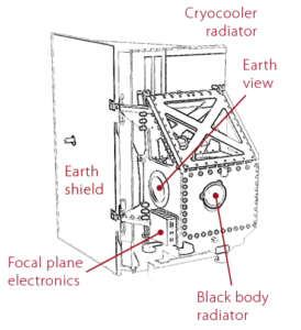
A diagram of TIRS-2 showing its main components. Image Credit: NASA Goddard Space Flight Center
Can you explain the significance of increasing the number of spectral bands acquired by the OLI’s instruments in Landsat 9 and 8?
To clarify, Landsat 9 is a near-duplicate of Landsat 8, and both satellites have the same complement of spectral bands. They both have an additional three bands compared to Landsat 7. These bands provide additional information on coastal environments (coral, bathymetry), water quality, cirrus cloud presence, and two thermal infrared bands (rather than one on Landsat 7) to better remove the effects of the atmosphere from the surface temperature maps.
Landsat satellites have been providing critical data on how the climate has been changing for almost 50 years. What does the future look like for this legacy?
We are starting to work on the follow-on mission, currently named Landsat Next. While plans are still tentative, we are scoping a system with several additional spectral bands for water quality and snow/ice studies, higher spatial resolution, and more frequent coverage. These are all enhancements requested by the user community, designed to support some of the key science and application areas of the 2030s.
Landsat 9 At Work
Video Credit: Nasa Goddard/YouTube.com
Where can readers find more information and stay up to date with the Landsat project missions?
Our Landsat Communications team maintains a robust social media presence. On the web, check out https://landsat.gsfc.nasa.gov/ for science stories and mission updates, and https://www.usgs.gov/core-science-systems/nli/landsat for access to data products from the Landsat archive at no cost.
About Dr. Jeffrey Masek
 Dr. Masek is a Research Scientist in the Biospheric Sciences Laboratory at NASA GSFC. His research interests include satellite-based monitoring forest dynamics, climate-change impacts on terrestrial ecosystems, and remote sensing techniques.
In 2015 he was appointed Project Scientist for the Landsat-9 mission, and from 2001-2010 he served as the Deputy Project Scientist for Landsat-8. He also served as Chief of the Biospheric Sciences Lab from 2014-2019. Dr. Masek received a B.A. in Geology from Haverford College (1989) and a Ph.D. in Geological Sciences from Cornell University (1994), and has held previous research positions with the University of Maryland, Hughes Information Systems, and Cornell University.
Disclaimer: The views expressed here are those of the interviewee and do not necessarily represent the views of AZoM.com Limited (T/A) AZoNetwork, the owner and operator of this website. This disclaimer forms part of the Terms and Conditions of use of this website.