By Kalwinder KaurMay 17 2012
Earthquake – or seismic – activity is unpredictable and can have a devastating impact on the affected countries. The earth’s surface is made up of tectonic plates that form the globe, moving both horizontally and vertically. A break along a fault (the place where two or more plates meet) under the earth’s surface forces the plates to rub together. The friction generated by this contact releases a burst of energy, causing a wave to ripple up through the earth’s crust and manifest as shaking on the surface.
The earthquake starts at its hypocenter, below the earth’s crust, and rises up to the surface of the earth at its epicenter (Figure 1). Plate boundaries become trapped at a fault so that the energy that is moving apart the two tectonic plates ripples up from the fault towards the epicenter when there is a sudden shift in these plates, making the surface shake.
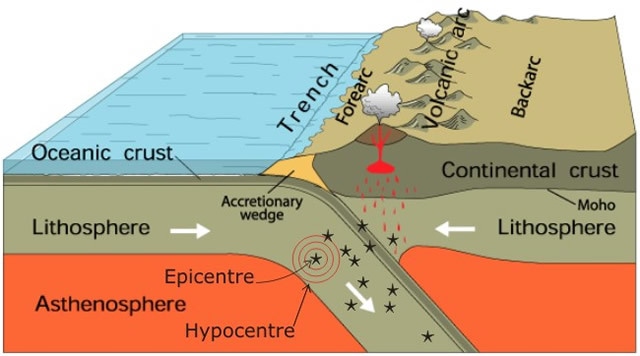
Figure 1. Basic principle to earthquake formation. The earthquake rupture will occur at the hypocenter beneath the Earth’s surface. The shift in both plates creates a series of vibrations that generate seismic waves resulting in an earthquake.
Global Statistics on the Frequency of Earthquakes
There are on average 500,000 detectable earthquakes on the planet each year, of which one fifth can be felt without sensors. All of these can be measured using a seismometer. The majority of earthquakes occur at plate boundaries (faults) along the oceanic and continental tectonic plates. Countries and areas near these faults like Japan, Indonesia, Western USA and New Zealand often experience large earthquakes. An earthquake is measured on a logarithmic (nonlinear) magnitude scale. Various scales are used by seismologists, but they all measure the amount of energy expelled by an earthquake. By applying seismology it is possible to track the number of earthquakes occurring over an annual period (see Table 1).Table 1. Number of earthquakes detected globally between the period of 2000 –2012. Statistics taken from the USGS National Earthquake Information Center.
Earthquakes (Magnitude 5+) Worldwide for 2002 - 2012
| Magnitude |
2002 |
2003 |
2004 |
2005 |
2006 |
2007 |
2008 |
2009 |
2010 |
2011 |
2012 |
| 8.0 to 9.9 |
0 |
1 |
2 |
1 |
2 |
4 |
0 |
1 |
1 |
1 |
2 |
| 7.0 to 7.9 |
13 |
14 |
14 |
10 |
9 |
14 |
12 |
16 |
23 |
19 |
5 |
| 6.0 to 6.9 |
127 |
140 |
141 |
140 |
142 |
178 |
168 |
144 |
151 |
185 |
49 |
| 5.0 to 5.9 |
1201 |
1203 |
1515 |
1693 |
1712 |
2074 |
1768 |
1896 |
2104 |
2276 |
672 |
| 4.0 to 4.9 |
8541 |
8462 |
10888 |
13917 |
12838 |
12078 |
12291 |
6805 |
10267 |
13315 |
3749 |
| 3.0 to 3.9 |
7068 |
7624 |
7932 |
9191 |
9990 |
9889 |
11735 |
2905 |
4329 |
2791 |
664 |
| 2.0 to 2.9 |
6419 |
7727 |
6316 |
4636 |
4027 |
3597 |
3860 |
3014 |
4624 |
3643 |
931 |
| 1.0 to 1.9 |
1137 |
2506 |
1344 |
26 |
18 |
42 |
21 |
26 |
39 |
47 |
19 |
| 0.1 to 0.9 |
10 |
134 |
103 |
0 |
2 |
2 |
0 |
1 |
0 |
1 |
0 |
| No Magnitude |
2938 |
3608 |
2939 |
864 |
828 |
1807 |
1922 |
17 |
24 |
11 |
1 |
| Total |
27454 |
31419 |
31194 |
30478 |
29568 |
29685 |
31777 |
* 14825 |
* 21562 |
* 22289 |
* 6092 |
| Estimated Deaths |
1685 |
33819 |
228802 |
88003 |
6605 |
712 |
88011 |
1790 |
320120 |
21953 |
125 |
Located by the US Geological Survey National Earthquake Information Center (M4.5+ for most of the world; doesn't include US regional network contributions)
Application for Seismometers in the study of earthquakes
The science of seismology is based on the idea of using a sensor to detect an earthquake and to measure its magnitude. Seismology also focuses on the effects of an earthquake, for example, a tsunami. A seismometer is a sensor comprising of an inertial mass component, which is mobile relative to the frame of the sensor, held to the frame by a spring. This attachment helps to block out any movements once the motion of the sensor frame stabilizes. The aim is to record the motion of the mass relative to the frame of the sensor. Any motion from an external source will move the frame. By being able to measure the motion of the base relative to the mass, the whole transition is transformed into an electrical voltage that is then recorded on a magnetic tape. By using the seismometer in this way, the movement of the ground can be measured (Figure 2).
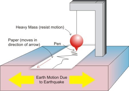
Figure 2. Basic Seismometer
With over 90% of earthquakes occurring underwater, the ocean-bottom seismometer (OBS) (see Figure 3) was designed for measuring movement underwater. The seismometer is only part of the system used to measure earthquakes underwater. The sensor is attached to additional components to help run the sensor, such as a data logger that requires batteries, a spherical weight to sink the sensor onto the ocean floor, and a controlled acoustic release and flotation device to lift the instrument back to the surface of the ocean. Due to the fact that seismic waves travel through the earth’s interior, an earthquake can also be detected by a seismometer from long distances.
Vertical Seismograph
Types of Ocean-Bottom Seismometer (OBS)
Short-Period Earthquake Seismometer
Smaller motion earthquakes have a much higher frequency, making it difficult to monitor these movements in one single measurement. This type of motion requires the measurement of such movements up to 100 times per second. The Woods Hole Oceanographic Institution (WHOI) D2 is a modern type of OBS with a six-month battery life. It measures seismic waves in horizontal and vertical directions while recording small and frequent earthquake activity, such as fissure vent activity.
Long-Period Earthquake Seismometer
Larger seismic waves are rare, so the long-period OBS is used to record these earthquakes with a time period ranging between approximately 0.1 and 40.0 seconds. WHOI long-deployment OBS and Scripps long-deployment OBS are both used for longer periods of time (up to one year or longer if necessary) to monitor the earth’s motion.
Challenges in the Application of Seismometer
OBS instruments are challenging to put in place whilst maintaining a high degree of accuracy, which when descending through thousands of meters of water can alter the quality of the data recorded. The aim is to set these sensors on the bedrock of the ocean rather than in a cluster of sediment which can cushion the motions being measured and provide inaccurate readings.
Another disadvantage to the short-term OBS instrument is the short life span – this type of sensor has to be reset over a 30 day cycle. However, these instruments are small in size, making the recovery of this sensor from the ocean a relatively easy task compared to long-term deployment seismometers. Furthermore, recording the data detected by the seismometers requires a large amount of memory of the drive holding the information. This also consumes the battery life for such short-term use sensors.
The design and method of application for seismometers is constantly evolving to try to eliminate limitations, with a rather interesting research area opening up for NASA and a cluster of academic institutes identified collaboratively as the READI (real-time earthquake analysis for disaster mitigation) network. This group has initiated research on an earthquake warning system that works by using satellite data from global positioning system (GPS) technology.
When focusing on areas commonly affected by earthquakes, such as Japan or Western USA, this system can help take more accurate measurements of an earthquake with timely warnings to prevent fatal displacement of water waves following an earthquake (i.e., a tsunami), a naturally occurring disaster seen in March 2011. The idea of this GPS-supported system involves positioning a series of GPS receivers along the North American coastal area, stretching these out to other heavily affected areas including California, British Columbia, and Canada. These sensors will work in synchronicity to record real-time motion activity moving through the ground as a reflection of local or distant seismic wave patterns, detecting shifts between two tectonic plate boundaries. Compared to the seismometer which finds it difficult to provide an accurate reading where you can distinguish between magnitude 8 and magnitude 9, a reading from the GPS satellite system will directly measure this without ambiguity.
Sources and Further Reading
- https://www.quakefinder.com/
- http://science.nasa.gov/science-news/science-at-nasa/2012/?page=3
- https://qvsdata.com/
- http://www.whoi.edu/oceanus/viewArticle.do?id=2509
- http://www.nature.com/news/satellite-system-will-speed-up-tsunami-warnings-1.10480
THis article was updated on 13th February, 2020.
Disclaimer: The views expressed here are those of the author expressed in their private capacity and do not necessarily represent the views of AZoM.com Limited T/A AZoNetwork the owner and operator of this website. This disclaimer forms part of the Terms and conditions of use of this website.