Apr 18 2018
Radar satellites provide the data used to map ocean currents and sea level. However, so far the radar's "eyes" have been blind in areas where the oceans are covered by ice. Scientists at the Technical University of Munich (TUM) have currently formulated a new analysis technique to solve this issue.
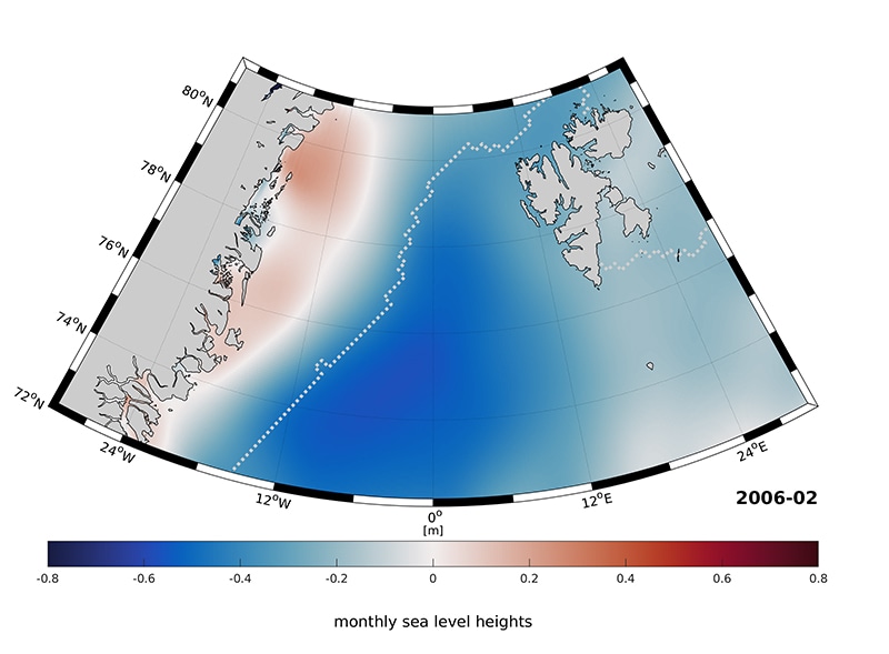 The ocean east of Greenland is covered by ice all year round (the white line shows the boundary of the oceanic ice). The water underneath is subject to a dynamic seasonal process and is influenced by the currents of the Atlantic ocean. (Image credit: Marcello Passaro, Felix Müller / DGFI-TUM)
The melting of the polar ice cap would have an extreme effect: Sea level would rise by several meters globally, impacting millions of people who live in coastal areas. "This means one of the most important questions of our time is how climate change is affecting the polar regions," explains Dr. Marcello Passaro of the TUM German Geodetic Research Institute.
The Blind Spot of the Radar "Eye"
But variations in ocean currents and sea level in the ice-covered regions of the Arctic and Antarctic specifically are very hard to detect. The reason: The radar signals of the altimeter satellites that have been inspecting the surfaces of the earth and oceans for more than twenty years are reflected by the ice at the poles. This renders the water below the ice invisible.
But ocean water also pushes through openings and cracks in the permanent ice, reaching the surface. "These patches of water are however very small and the signals are highly distorted by the surrounding ice. Here standard evaluation methods like those used for measurements made on the open seas are incapable of returning reliable results," Passaro emphasizes. Along with an international team, he has at present developed a data analysis technique which optimizes the focus of the radar's eyes.
An Algorithm for All Occasions
The heart of this virtual "contact lens" is the adaptive algorithm ALES+, (Adaptive Leading Edge Subwaveform). ALES+ automatically detects the portion of the radar signal which is reflected by water and derives sea level values using this data alone.
This facilitates precisely measuring the altitude of the ocean water which reaches the surface through openings and ice cracks. By comparing a number of years of measurements, oceanographers and climate researchers can presently draw conclusions about variations in ocean currents and sea level.
The special thing about our method is that it is adaptive. We can use one and the same algorithm to measure sea level in both open and ice-covered ocean areas. ALES+ can also be used for coastal waters, lakes, and rivers. Here the signals are highly varied, but always exhibit certain characteristic properties which the system then learns.
Dr. Marcello Passaro
The researchers were able to use a test location in the Greenland Sea to show that ALES+ returns water levels for ice-covered and open ocean regions which are considerably more precise than the results of earlier evaluation techniques.