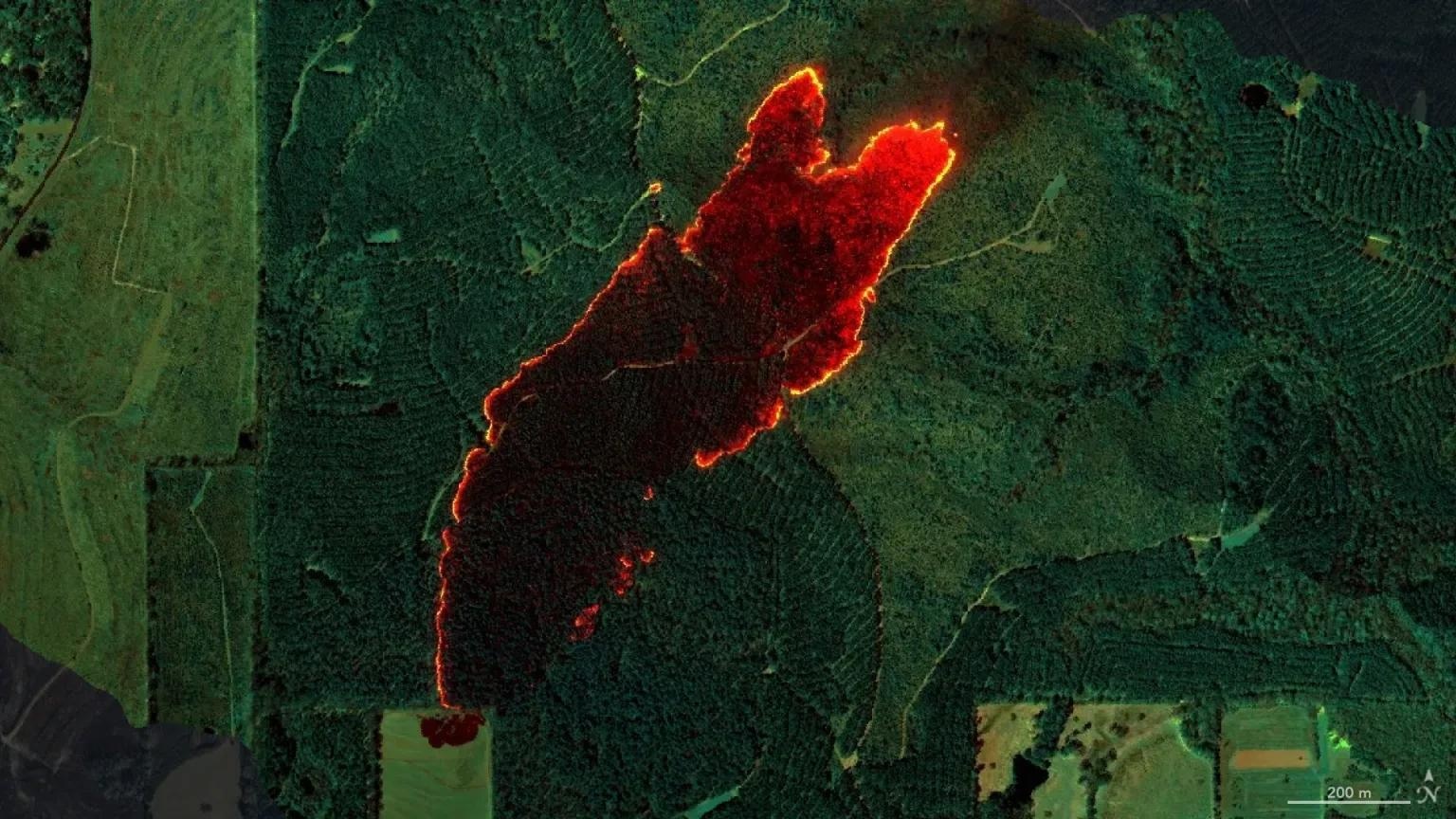
NASA's sensor was used to map a wildfire near Castleberry, Alabama, on March 19. Within minutes, the image was transmitted to firefighters on the ground, who used it to contain the blaze. Image Credit: NASA/JPL-Caltech, NASA Earth Observatory
Wildfires are notoriously difficult to manage, fueled by unpredictable behavior and the potential to spread rapidly across large areas. Traditional monitoring methods, like ground patrols, drone footage, and satellite imagery, are valuable but can sometimes lack the speed or detail needed during the early stages of a fire.
Airborne sensors offer a middle ground, combining the resolution of satellite tools with faster data delivery. Flying at around 9000 feet (about 3000 meters), AVIRIS-3 captures detailed thermal and spectral data in real time. It’s specifically designed to scan infrared wavelengths, which are invisible to the human eye but critical for identifying heat sources, burn areas, and vegetation status.
This effort is part of NASA’s FireSense Airborne Campaign, which focuses on monitoring wildfire and prescribed burn activity across southern states like Alabama, Mississippi, Florida, and Texas.
How AVIRIS-3 Works
AVIRIS-3 collects reflected energy in three key infrared bands that are especially sensitive to thermal changes. Mounted on a King Air B200 aircraft, the sensor flies directly over fire zones, scanning the landscape below and generating a comprehensive view of fire intensity, ground temperature, and burn progression.
Flights are conducted both in anticipation of controlled burns and in response to emerging wildfires. Once over a fire area, the sensor produces multispectral imagery that pinpoints thermal hot spots - high-heat zones where fire activity is most intense. These images are translated into color-coded maps showing cooler and hotter areas, fire perimeters, and remaining unburned vegetation.
One of AVIRIS-3’s strengths is how quickly this data can be processed - often within minutes of a flight. Using onboard or ground-based systems, the sensor's readings are turned into detailed maps that are then sent to firefighting teams via satellite internet. This gives crews real-time insight into fire behavior and helps guide decisions about containment, firebreak placement, and where to allocate resources.
What the Data Shows
AVIRIS-3 is already proving its value in the field. In Alabama, it helped identify a 120-acre fire that hadn’t yet been reported, giving response teams a critical head start. The detailed thermal maps allowed firefighters to target the most intense areas and understand the fire’s boundaries with greater accuracy - vital for controlling spread before it escalates.
By highlighting burn scars and lingering hot spots, the sensor provides a clearer picture of fire behavior, especially in complex situations near homes or infrastructure.
In one case near Perdido, Alabama, thermal data showed that heat sources were well-contained, which allowed crews to redirect attention to newer threats near Mount Vernon. That kind of precision supports smarter, more efficient firefighting, like deploying teams to the areas of greatest need or preemptively cutting firebreaks.
A More Informed Approach to Firefighting
AVIRIS-3 shows how advanced sensing technology can support a faster, more informed wildfire response. Its ability to deliver near-instant, high-resolution thermal maps is helping fire crews detect previously unreported fires, monitor active ones in real time, and respond with greater precision.
As NASA continues refining this system, its integration into wildfire management could lead to even more responsive strategies - ones that harness data to meet one of today’s most pressing environmental challenges.