To avoid a repetition of the 2004 Boxing Day tsunami, GITEW, the German-Indonesian tsunami detection and warning system was launched. EU closely followed by spearheading the ‘Distant Early Warning System (DEWS)’ to offer protection to the Indian Ocean region’s nations.
DEWS has now developed and commenced deployment of a sustainable system for sensing and analyzing seismic events occurring in the Indian Ocean, quickly evaluate their potential to unleash a tsunami, and warn the at-risk nations in time to save lives.
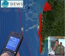 DEWS GITEWS Tsunami Detection and Warning System
A network of detectors strategically deployed in the ocean region forms the basis of the effective tsunami warning systems. The DEWS include ocean bed pressure control gadgets, broadband seismometers, and gauges. Various types of sensors offer complementary information for accurately assessing the risk due to a tsunami.
The data created by this instrument suite is transmitted through communication satellites to the Jakarta, Indonesia-based central station for subsequent processing. A new generation open source software that is known as ‘SeisComP3’ was created by the DEWS project prototypes’ lead institute, the German Research Centre for Geosciences (GFZ). This software helps to find out a seismic event’s latitude and magnitude rapidly.
When a powerful earthquake capable of generating a tsunami is detected by the system, the system commences analyzing this quake and models the risk due to the tsunami. In case the detected waves are from the pressure sensors installed on the ocean beds or newly created GPS buoys at the ocean surface, it is likely that a tsunami has formed and can strike somewhere. The next issue to be resolved is the place and the run-up height where the tsunami strikes.
DEWS researchers are utilizing libraries with data related to temblors of various source locations and magnitudes, along with in-depth detailed simulations of the waves likely to be generated around the entire coast line of the Indian Ocean coastline.
Whenever an actual earthquake strikes the region, the DEWS system is able to find the event’s best fit simulation automatically for ascertaining the coastal regions that are at risk.