A whole new technology has come into use for producing aerial photogrammetry three dimensional (3D) imagery – enough to make nerds like me pretty excited.
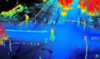 Example of LiDAR Digital Surface Model (DSM) oblique view. From Michigan Statewide Authoritative Imagery & LiDAR Program ENMUG ] March 25, 2014 by Everett Root and Josh Ross, Michigan Technology, Management, & Budget
About seven years ago my nieces’ husband was showing me some new technology that he was using as a land surveyor when working for an engineering firm in Ann Arbor (you know, that suburb of Ypsilanti where that other university is located). He explained it like this: Mounted on a tripod the computer machine sends a beam of light out, and tracks the length of time for the light reflection to return. The machine knows where it is located, and the direction and vector it sent the beam of light. With the time it took for the reflection to return, it can compute the distance and position of the surface the light reflected from. It also records 100s of properties of the reflected light – indicating the color, texture, and material, of the surface as well as much more. Then it repeats the process, moving up and down vertically, then again for the next row over horizontally.
When done it produces a digital cloud of millions of dots. Those data are used by a computer to create three-dimensional images of the subject(s). My nephew-in-law used the technology to do things such as document severe traffic accident scenes, and to create or check as-built documentation of things like the new Tiger stadium, Comerica Park, in downtown Detroit.
Today, very similar technology is flown in an airplane to collect very accurate 3D imagery of the ground as the plane flies over. This remote sensing technology is called airborne LiDAR (Light Detection And Ranging). At this time, the Michigan Department of Management and Budget’s Michigan Statewide Authoritative Imagery and LiDAR (MiSAIL) program offers the option of partnering with local governments for a cooperative, shared price, to collect airborne LiDAR.
The aerial sensor scans the landscape recording the reflected laser pulses, uses Global Positioning System (GPS) (see also this GPS tutorial) technology to precisely track the location of the aircraft and records data from the Inertial Measurement Unit (IMU) about the 3D attitude of the aircraft. The laser pulses occur every 0.002 to 0.01 second. The LiDAR sensor records not only the 3D location of the reflection points, but also the intensity of the reflected return, along with a myriad of other properties of the return signal. The “quality level 2” LiDAR that the MiSAIL program offers has a density of reflected pulses which allows the extraction of elevation contours accurate to within one foot, with points spaced 0.7 meters (about 2.25 feet) apart (i.e., two reflected points in each square meter (about 5.33 square feet).
The result is a huge point cloud of data, with each 3D point location known and calibrated. With appropriate software and computer expertize the cloud of points can be used to create an air-photo-like image; show the bare-earth surface of the landscape, looking beneath forest vegetation; creating three dimensional imagery of the ground and objects on the ground, oblique views and much more.
Using the point cloud of data a customer can receive data in an ASCII point file, raster grid data file or in ERDAS .IMG format. The appropriate specifications of these data, the format it should be delivered in, and a host of other options are complex and require detailed knowledge to make sure a usable product is delivered. The point cloud data can be processed so it can be used with Geographic Information System (GIS) software (see also this GIS tutorial).