The next time you're digging for buried treasure, stop when you hit water. That underground resource is more valuable than all legendary hoards combined. Ninety percent of Earth's available fresh water is beneath the surface at any particular time. We drink it, we grow our food with it, and we power industries with it.
 Urban growth in Milan, Italy. In this region, urbanization has increased the potential for groundwater contamination. Image credit: Wikimedia Commons
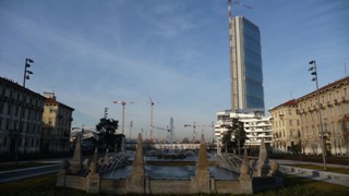
We also pollute it. When pollutants get into groundwater, they can stay there for decades. Cleanup efforts are difficult, expensive and not always successful. It would be better to protect groundwater from contamination in the first place, but risks to groundwater are moving targets. Although unchanging factors such as porous soil or shallow aquifer depth play a role, the greatest risk comes from the source of the pollutants: people. And people are always moving. A growing city, in particular, usually means a growing threat to groundwater quality. To lock on to the moving target of groundwater risk, planners worldwide need up-to-date information on how people are changing the land surface.
Son Nghiem, a research scientist at NASA's Jet Propulsion Laboratory in Pasadena, California, has devised a new technique to use satellite observations of changes in land use to assess the threat of groundwater pollution by a common group of polluting compounds called nitrates. "To test the method, we successfully conducted the Po Plain Experiment [POPLEX] in northern Italy," said POPLEX leader Marco Masetti, a professor at the University of Milan, Italy. Combining data from the experiment with satellite data and two other data sets on population and land use, they discovered that in this region, groundwater is more vulnerable in urban than in agricultural areas. The satellite data produced a more accurate map of groundwater risks than either of the other data sets.
Nghiem's new technique uses data from NASA's QuikScat scatterometer, a satellite managed by JPL. The method improves the "focus" of the QuikScat image from a pixel size of about 15 miles (25 kilometers) per side to 0.6 mile (1 kilometer) per side, capturing far more detail on how the landscape has changed. Nghiem explained his technique takes advantage of the fact that human-made structures bounce back more of the radar signal than does soil or vegetation. Since large buildings with steel frames are concentrated in cities, the strength of the return signals is a good measure of urbanization.
Lombardy, the region of Italy where the POPLEX experiment took place, "is both one of the most urbanized and one of the most agricultural regions in Italy," said Stefania Stevenazzi, a doctoral candidate at the University of Milan and lead author of a paper on the research, which appears in the March 19 Hydrogeology Journal. The city of Milan is in the north, and the southern part of the region is mainly farmland. Lombardy's farmers have usually been blamed for nitrate pollution in the region's aquifers because nitrates are used as fertilizers, but the compounds also have urban sources, including leaks from sewage systems.
The research team produced three groundwater vulnerability maps based on observed changes from 2000 to 2009. Each map used the same hydrological and geological data, but a different data set representing human factors: census results, a high-resolution aerial photographic survey and the QuikScat observations processed by Nghiem's method. Statistical techniques were applied to rank the vulnerability of every part of the plain. Water samples from about 200 wells were used to verify the results.
The three maps agreed that in Lombardy, urban sources of nitrate were more important than the rural in polluting groundwater. The QuikScat map, however, proved to match the water samples most accurately. For example, the map using census data indicated that several areas in greater Milan were not at much risk, whereas the satellite data caught the reality that these areas are highly vulnerable. That is because censuses place people at their home addresses, but most of the people in Milan's labor force are commuters who spend many waking -- and polluting -- hours at work.
Stevenazzi added, "Our analysis shows how much changes in land use were related to increasing or decreasing contamination in the 2000s. These results are also useful to evaluate how future land-use plans can be developed appropriately to safeguard groundwater quality and human health."