Mar 16 2010
The Open Geospatial Consortium, Inc. (OGC) has requested comments from the public, on its draft OGC Sensor Web Enablement (SWE) Common Encoding Standard.
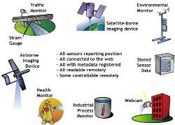
 Sensor Web Enablement (SWE) Overview
Version 2.0 of the standard offers a common encoding of data for use in the entire standards suite of OGC Sensor Web Enablement (SWE). The SWE Common standard helps to precisely outline the nature, representation, encoding, and structure of data related to sensors. The model is utilized to describe static files or dynamic data, along with data streaming data in the real-time environment, inputs and outputs for web services, processes, and data subsets. The model can handle various sensor observation categories that range from basic temperature information in situ to satellite-based images and full motion video that is streamed from the aircraft.
The SWE Common Language, an XML version of the model, is also utilized by various other current standards of OGC Sensor Web Enablement, for instance, Sensor Planning Service (SPS), Sensor Observation Service (SOS), Sensor Model Language (SensorML), and Sensor Alert Service (SAS). The draft OGC SWE Common 2.0 standard, along with information related to forwarding public comments on the document, is available from http://www.opengeospatial.org/standards/requests/63. Members of the public are required to forward their comments by 14 April 2010.
The OGC, an international consortium, comprises government agencies, more than 390 companies, research organizations, and universities taking part in a consensus process for the creation of geospatial standards that are publicly available. OGC standards back interoperable solutions. These solutions ‘geo-enable’ mainstream IT, the Internet, location-based and wireless services. Technology developers can use the OGC standards to render geospatial services and information accessible, as well as make the services and information useful for applications that have to be enabled geospatially.