The RapidScat instrument that flies aboard the International Space Station saw Typhoon Maysak's strongest winds wrapped tightly around its center, extending outward to over 30 miles from the eye. Maysak weakened as a result of increasing wind shear.
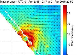 On April 1 from 19:17 to 20:50 UTC the ISS-RapidScat instrument captured the strongest sustained winds on Super Typhoon Maysak around the center and north of center reaching 30 m/s (dark red). Credit: NASA JPL, Doug Tyler
On April 1 from 19:17 to 20:50 UTC (3:17 p.m. to 4:50 p.m. EDT) the ISS-RapidScat instrument measured the sustained winds of Maysak, now a typhoon in the Northwestern Pacific Ocean. RapidScat saw the strongest sustained winds on Typhoon Maysak wrapped tightly around the center and north of center up to 30 m/s (67.1 mph/108 kph).
The Philippine Atmospheric, Geophysical and Astronomical Services Administration known as PAGASA issued a weather bulletin for the northern Philippines as Maysak, known locally as Chedeng, approaches. PAGASA expects to raise Public Storm Warning Signal #1 over Bicol and Samar Provinces, possibly suspending sea travel over those areas. PAGASA warned of moderate to heavy within the 150 to 200 km (93.2 to 123.4 miles) radius of the typhoon, and flash flooding in low-lying areas. Heavy rains are also likely to cause landslides in mountain slopes particularly over Aurora-Isabela area. Storm surges and sea surface waves of up to 4 meters (13.2 feet) are possible over the eastern coast of Samar, Bicol and Aurora-Quezon.
At 1500 UTC (11 a.m. EDT), Typhoon Maysak's maximum sustained winds had dropped to 105 knots (120.8 mph/194.5 kph), bringing it out of super typhoon status. As seen in wind data from NASA's ISS-RapidScat, those hurricane-force winds were huddled close to the center of circulation, extending out 30 nautical miles (34.5 miles/55.5 km) from the center.
Maysak was centered near 13.2 north latitude and 132.6 east longitude, about 681 nautical miles east of Manila, Philippines. Maysak was moving to the west-northwest at 8 knots (9.2 mph/14.8 kph)
According to the Joint Typhoon Warning Center (JTWC), strong increased vertical wind shear continues to weaken the storm. JTWC noted in their discussion that an "SSMI image reveals erosion of deep convection over the western semi-circle with the bulk of deep convection displaced over the northeast quadrant, however, the system eyewall remains intact with a microwave eye feature."
Maysak is moving west to west-northwest through the Philippine Sea, and toward the northern Philippines. The JTWC is forecasting landfall as a typhoon in the Cagayan Valley region late April 4 (Universal Time). PAGASA said that Maysak is estimated to make landfall over eastern coast of Aurora or Isabela by late Saturday (April 4) to early Sunday (April 5).
Maysak is expected to weaken to a tropical depression as it moves in a northwestern direction across the northern Philippines and re-emerges into the South China Sea on April 5.