Garmin International Inc., a unit of Garmin Ltd., the global leader in satellite navigation, today announced a comprehensive radar altimeter solution that expands upon Garmin’s high-performance, all-digital GRA 5500 radar altimeter to include the GRA 55, a best-in-class and cost-effective radar altimeter designed specifically for helicopters and general aviation aircraft.
The GRA 55 leverages Garmin’s patent-pending digital signal processing technology that works to provide smooth altitude tracking and results in a consistent and highly accurate above ground level indication, even in the most challenging environments such as rough terrain, tree canopies, sand and choppy water. The new GI 205 stand-alone indicator, designed to pair with the GRA 55 or GRA 5500, provides a comprehensive, stand-alone radar altimeter solution for operators seeking a cost-effective display.
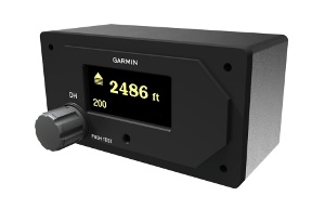 GI 205 Stand-Alone Radar Altimeter Indicator (Photo: Business Wire)
“Garmin is excited to extend our industry-leading radar altimeter products to a broader range of markets, while meeting the latest design standards and ultimately providing pilots with rock-solid confidence of their altitude above ground,” said Carl Wolf, Garmin’s vice president of aviation sales and marketing. “In addition to meeting the most rigorous altitude accuracy requirements only previously seen in products for transport and military aircraft, the GRA 55 and GI 205 help fulfill recent FAA requirements for radar altimeter equipage in commercial helicopter operations.”
Patent-pending technology in the GRA 55 incorporates built-in self-test monitors that continuously cross check system and data integrity, assuring the pilot of an accurate measurement of the height above ground. This technology also provides for a simpler installation with easy calibration and eliminates the requirement for long lengths of antenna cables that are traditionally required in the installation of radar altimeters.
The GI 205 stand-alone indicator features a vibrant OLED display with full 180-degree viewing angle, allowing radar altimeter indications to be seen easily in all types of flight conditions, day or night. Visual and audible alerts are available to ensure all altitude indications are clearly presented in-flight. Pilot-selectable decision height (DH) is easy to adjust using a knob and upon arrival at the DH, a “minimums, minimums” voice callout or traditional audible tone is available. Adding to situational awareness, an intuitive graphical trend indicator displays vertical velocity information, such that altitude trend can be monitored at a glance and corrections can be made promptly to avoid inadvertent climbs or descents.
For Part 135 helicopter operators, the GRA 55 fulfills the radar altimeter equipage requirement recently established by the FAA. When paired, the GRA 55 and GI 205 provide the best-in-class solution to meet these new requirements. Coupled with the GI 205 stand-alone indicator, operators can incorporate a complete, cost-effective radar altimeter solution into their flight deck.
The GRA 55 is expected to be available in the 2nd quarter of this year for a list price of $6,995 and is compatible with select Garmin integrated flight decks and flight displays, as well as some third-party displays. The GI 205 is anticipated to be available in the 4th quarter of this year for a list price of $3,995. A complete GRA 55 and GI 205 package (including antennas) will be available for an introductory list price of $11,995. For complete compatibility details and additional information contact a Garmin authorized dealer.
Garmin’s aviation business segment is a leading provider of solutions to OEM, aftermarket, military and government customers. Garmin’s portfolio includes navigation, communication, flight control, hazard avoidance, surveillance, and other products and services that are known for innovation, reliability, and value. For more information about Garmin’s full line of avionics, go to www.garmin.com/aviation, www.garmin.blogs.com and https://twitter.com/garmin.